

Major Hurricanes That Have Struck the Florida Panhandle over the past 50 Years
Major Hurricanes That Have Struck the Florida Panhandle over the past 50 Years
Last Updated: October-2026
Over the past 50 years, the Florida Panhandle has been struck by 14 named storms (2026 data not official yet)—six hurricanes and seven tropical storms—each leaving behind a trail of transformation. From Hurricane Kate’s 1985 landfall to Hurricane Michael’s devastating Category 5 impact in 2018, these events have shaped the coastline, challenged infrastructure, and tested the resilience of local communities. This post explores the most significant storms to hit the region, what they’ve taught us, and how they continue to influence life along the Gulf.
Planning a trip to Florida’s Emerald Coast? Explore Things to do on 30A and the Best time to visit before you book.
A History of Tropical Storms and Hurricanes in the Florida Panhandle
The Florida Panhandle and particularly Florida’s Emerald Coast, stretching out 60 miles of Destin, FL has a long history of being in the path of powerful hurricanes and also has had its share of tropical storms. Over the past 50 years, this region has seen numerous storms make landfall, each leaving its mark on the landscape and the lives of its residents.
After analyzing the extensive dataset that NOAA has pulled together – Since 1976, there have been 13 named storms either classified as a Hurricane or Tropical Storm. Of those 13 storms, 7 were classified as Tropical Storms and 6 were classified as Hurricanes. The distinction is that Hurricanes are classified as having a wind speed > 74mph and Tropical storms fall < 74mph. Hurricanes can be classified as Category 1 through 5 with 1 being the least impactful and 5 being the most destructive.

These storms, among others, have shaped the history and resilience of the Florida Panhandle.
Florida Panhandle Hurricanes Since 1976

Some of the most notable hurricanes since 1976 include:
- Hurricane Kate (1985): Made landfall near Mexico Beach east of Panama City as a Category 2 hurricane with winds of 100mph.¹
- Hurricane Erin (1995): Made landfall near Pensacola Beach as a Category 1 hurricane with winds of 85mph.¹
- Hurricane Opal (1995): Made landfall near Pensacola Beach as a Category 3 hurricane with winds of 115mph.¹
- Hurricane Earl (1998): Made landfall east of Panama City as a Category 1 hurricane with winds of 80mph.¹
- Hurricane Dennis (2005): Made landfall on Santa Rosa Island near Pensacola as a Category 3 hurricane with winds of 120mph.¹
- Hurricane Michael (2018): Made landfall near Mexico Beach west of Panama City as a Category 5 hurricane with winds of 160mph.¹
- Hurricane Isaias (October 9, 2026) – Made Landfall near Destin, FL as a Category 2 hurricane with winds approaching 100mph. Will be updated as storm details become official.
¹Source Wikipedia
Visiting 30A during hurricane season? Read the Vacation-30a’s complete Hurricane Preparedness on 30A guide — including evacuation routes, a packing checklist, and travel insurance tips.
Make sure you have the right gear — including a NOAA weather radio. See this Beach Essentials Guide for everything we recommend for Gulf Coast visitors.
Update – Post Tropical Cyclone Isaias (October 10, 2026)
Updated Saturday, Oct. 10, 12:30 p.m. CT
IIsaias came ashore Friday night near Destin, at about 8:30 p.m. CT, as a Category 2 hurricane with 105 mph winds, according to The Weather Channel. The National Hurricane Center had measured it at 115 mph just a couple of hours earlier. It was the first hurricane of the 2026 season.
That track put 30A on the east side of the storm, the side forecasters were most worried about. Going in, NHC forecast 6 to 9 feet of storm surge from the Alabama line to Grayton Beach, which includes the West End of 30A, and 4 to 7 feet from Grayton east to Indian Pass.
By Saturday morning, Isaias had weakened into a post-tropical system over central Alabama. Here’s where things stand at home:
- Walton County’s mandatory evacuation for Zones A, B and C was issued Thursday. As of this update, we haven’t seen the county announce reentry.
- Power is out across much of the county. CHELCO crews are working to restore service.
- Water: Walton County Emergency Management is asking everyone to limit water use.
- Rivers are still rising. NHC says significant river flooding in the western Panhandle will crest through Sunday.
- The Gulf is still rough. Dangerous surf and rip currents are expected through the weekend.
We don’t know yet how 30A itself came through. We’ll add what we learn here, and our own update on 5Tides is just below.
For the official word, follow Walton County Emergency Management and the county’s re-entry process.
More details on Hurricane Isaias 30A Current Conditions here.
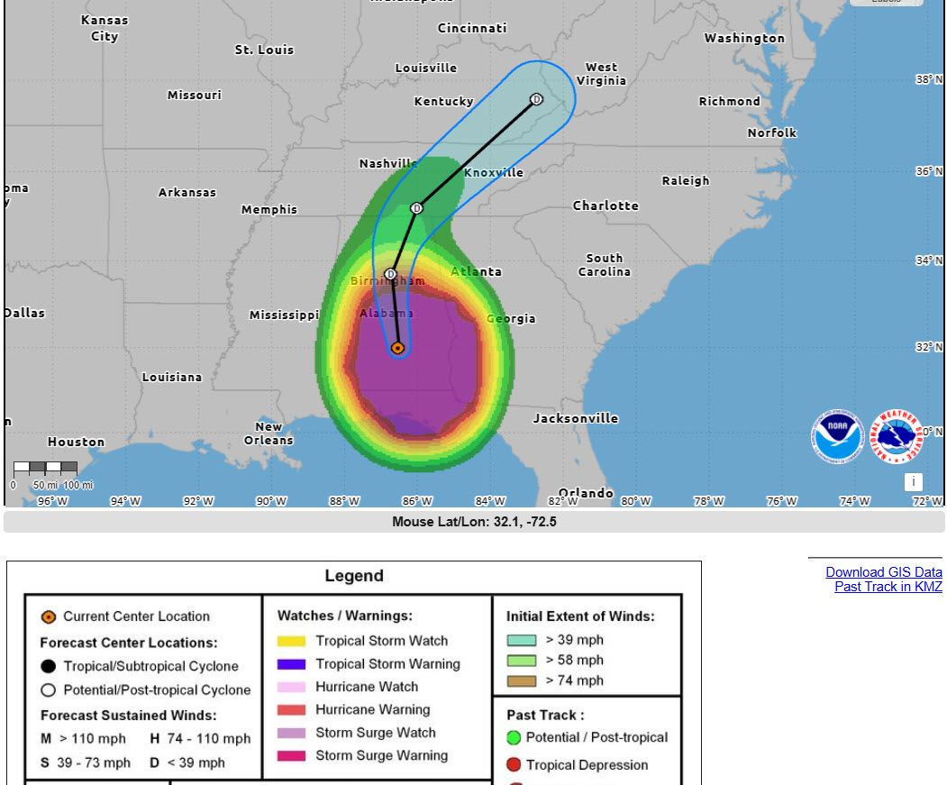
Update – Hurricane Isaias (October 9, 2026)
Updated Saturday, Oct. 10, 7:30p.m. CT
Isaias is coming ashore tonight on the western Florida Panhandle. At the National Hurricane Center’s 7 p.m. CT advisory, the center was about 45 miles southeast of Pensacola, moving north at 18 mph. It had 110 mph winds, and landfall was expected within an hour or two. The Weather Channel has it making landfall near Destin.
That puts 30A on the east side of the storm:
- Storm surge is the big one for the West End. NHC is forecasting 6 to 9 feet above ground from the Alabama line to Grayton Beach. That stretch includes Topsail and the West End of 30A. From Grayton east to Indian Pass, the forecast is 4 to 7 feet.
- The wind is gusty and reaches a long way. Hurricane-force winds extend about 35 miles from the center, and tropical-storm-force winds reach about 205 miles. NHC expects Isaias to be gustier than a typical hurricane. A station in Gulf Breeze has already recorded a 97 mph gust.
- There’s a tornado risk tonight, greatest east of the center, across the Panhandle and into south Georgia.
- More rain is coming: 4 to 8 inches across the Panhandle, with up to 15 in spots.
Isaias should weaken quickly once it’s inland. NHC forecasts it to lose its tropical characteristics over Alabama by Saturday afternoon.
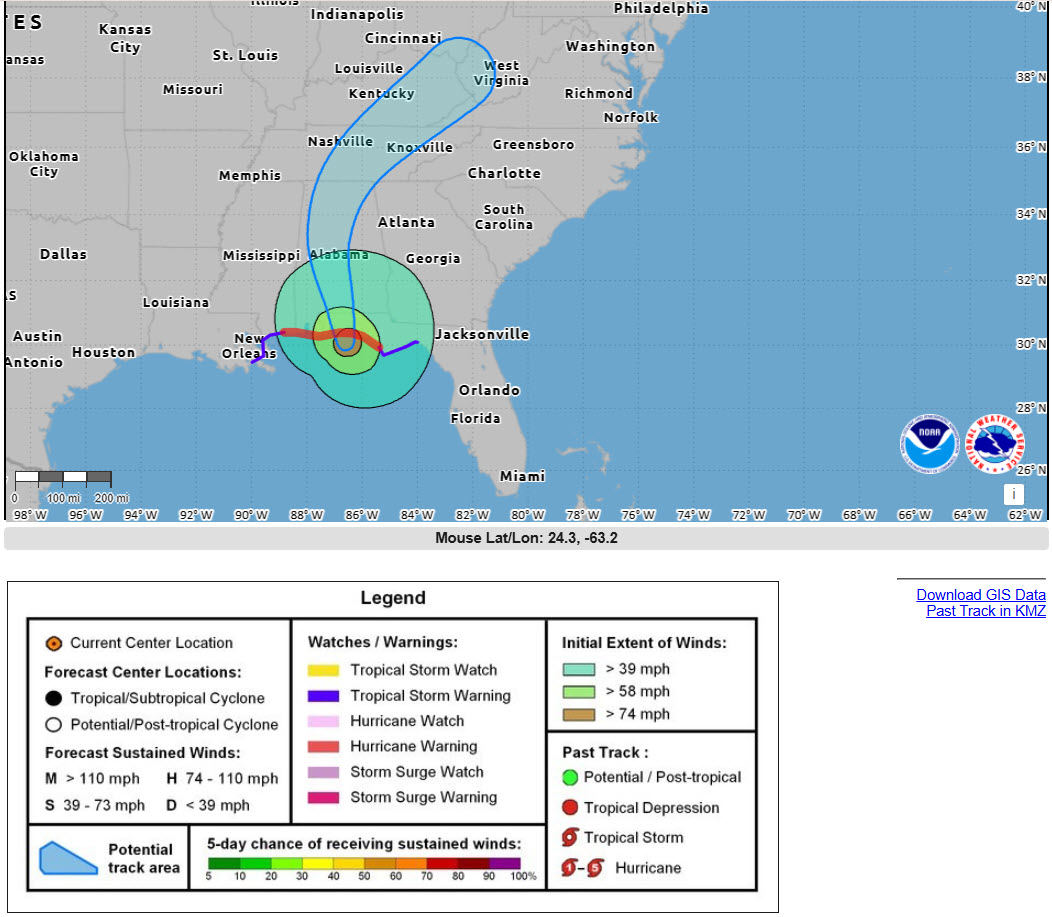
Here’s what matters if you have a trip on the books:
- 30A is inside the Hurricane Warning, which runs from Ocean Springs, Mississippi, to the Bay/Gulf County line. Landfall is expected late Friday or early Saturday somewhere in that stretch.
- Walton County ordered a mandatory evacuation for Zones A, B and C, effective noon Thursday. The county was clear that this one is about storm surge, up to 7 feet, more than wind.
- The water is the story again, and so is the rain. NHC is forecasting 4 to 8 inches across the Panhandle, with up to 15 in spots, plus an isolated tornado risk starting Friday night.
Our guests left Thursday night under the county’s mandatory evacuation, and we’re glad they did. We’ll get eyes on the condo as soon as Walton County allows reentry, and we’ll post what we find right here.
If you’re booked with us in the coming weeks, we’ll reach out to you directly. Until then, the official word comes from the National Hurricane Center and Walton County Emergency Management.
Tropical Storm Bertha (July-2026)
We logged the first tropical system to brush our stretch of coast in 2026: Tropical Storm Bertha, the second named storm of the Atlantic season.
Bertha started life as Tropical Depression Two, spinning up in the Gulf about 155 miles south of Panama City on Sunday, July 19. It was a slow mover — barely crawling north at 2 mph — before strengthening into Tropical Storm Bertha late Monday, July 20, with peak sustained winds near 60 mph. From there it tracked west along the northern Gulf, stayed offshore, and eventually set its sights on southeast Louisiana. New Orleans, not the Panhandle, took the brunt of it.
Here’s the important part for anyone who was on 30A that week: Bertha never made landfall in Florida. The center stayed out over the Gulf, and the system was lopsided — its heaviest weather sat well south of the center, offshore. Even so, coastal Walton and Bay Counties were placed under Tropical Storm Warnings, and the practical impact was real:
- Double red flags up and down the coast. Our beaches were closed to swimming for several days. The National Weather Service issued High Surf Warnings and a high, life-threatening rip current risk — the kind of surf that pulls strong swimmers out fast.
- Rough surf and dangerous rip currents that lingered even after the rain cleared. This was the real story locally: not wind damage, but water you simply had to stay out of.
- Squally rainbands rolled onshore with gusty winds in the 30–40 mph range, and an isolated tornado risk was tucked inside the stronger cells.
- Minor coastal flooding was possible in low-lying spots, and a modest 1–3 foot surge was forecast for the adjacent Florida coast — nothing like the surge that hit areas closer to Louisiana.
- A National Ocean Service station at Panama City Beach clocked 45 mph sustained winds and a 57 mph gust at the peak. Enough to get your attention; not enough to do widespread damage here.
By midweek, as Bertha pulled away to the west, conditions gradually improved and the flags started coming back down.
The takeaway is the one we come back to every season: on 30A, the tropical-storm story is usually the water, not the wind. You don’t need a landfall to get days of dangerous surf. If you’re visiting during hurricane season, watch the beach flags like a hawk — a double red means the Gulf is closed, no exceptions — and check live conditions before you head down to the sand.
You can see current flags and live conditions anytime on the 30A Beach Cams page, and if a system ever has you second-guessing your dates, learn more in the Hurricane Preparedness on 30A guide that walks through everything we tell our own guests.
A Period of Relative Calm (Prior to 2026)
Despite the recent impact of Hurricanes Helene and Milton to Southern Florida and the rest of the Southeast US, it is worth noting that the Florida Panhandle (and Florida’s Emerald Coast) has experienced a period of relative calm (prior to 2026). It has been several years since a major hurricane made landfall in this area, allowing communities to rebuild and strengthen their defenses against future storms. It is always important to stay vigilant going forward as Mother Nature has a tendency to make her own determinations.
Check live beach and weather conditions anytime here 30A Beach Cams.
5Tides: Our Hurricane Isaias Update
Updated Saturday, Oct. 10, 2026
We’re not open for guests right now. When Walton County ordered a mandatory evacuation on Thursday, our guests packed up and headed out that night. Guest safety is always of the utmost importance.
That’s a different story from Tropical Storm Bertha in July, when guests stayed right through it and the biggest change to their week was trading the Gulf for the pool. Isaias was a hurricane with a storm surge warning, and the county’s call was clear.
We haven’t been able to see the condo yet. Walton County hasn’t opened reentry, and we’ll go in as soon as it does. Once we’ve seen the place, we’ll post an honest update right here: what we found, and when we’ll be ready for guests again.
Booked with us in the coming weeks? We’ll contact you directly, so you don’t need to keep checking here.
Ready to plan your trip? Check out Things to Do on 30A, browse the 30A Events Calendar, or find the Best Time to Visit.
Frequently Asked Questions: Hurricanes & the Florida Panhandle
What is the most destructive hurricane to hit the Florida Panhandle?
Hurricane Michael, which made landfall near Mexico Beach on October 10, 2018, is the most destructive hurricane on record for the Florida Panhandle. It came ashore as a Category 5 with sustained winds of 160 mph — the strongest Panhandle landfall ever recorded and only the fourth Category 5 landfall in U.S. history. It caused approximately $25 billion in damage and was directly responsible for 16 deaths.
Has a hurricane ever directly hit Santa Rosa Beach or Highway 30A?
No major hurricane has made a direct landfall on Highway 30A or Santa Rosa Beach specifically. The Panhandle’s most significant storms — including Opal (1995), Ivan (2004), Dennis (2005), and Michael (2018) — made landfall east of 30A near Pensacola, Fort Walton Beach, or Mexico Beach. That said, 30A has experienced tropical storm force winds, storm surge, and heavy rainfall from storms tracking nearby, and evacuations have been ordered for the area during several of these events. Will update this post as information becomes available on Hurricane Isaias which made landfall near Destin on October, 9, 2026 as a CAT 2 Hurricane.
What months are most dangerous for hurricanes on the Florida Panhandle?
Hurricane season officially runs June 1 through November 30, but the peak threat window for the Gulf Coast and Florida Panhandle is August through October. Historically, the most significant Panhandle storms have made landfall between late September and mid-October.
Is it safe to vacation on 30A during hurricane season?
Many visitors enjoy 30A during hurricane season, particularly in June, early July, and November when activity is typically lower and crowds are thinner. The key is staying informed. The vast majority of hurricane season days on 30A are sunny and beautiful — but having a plan and monitoring conditions is always smart. Hurricane Preparedness on 30A.
What should I do if a hurricane threatens during my 30A vacation?
Monitor NOAA alerts and Walton County Emergency Management closely. If a mandatory evacuation is issued for your zone, leave early — Highway 98 and I-10 can back up for hours. Head north on US-331 or US-79 to get at least 100 miles inland. Before leaving, photograph the rental property and notify your host. For a complete checklist of what to pack, evacuation routes, and local resources, visit our Hurricane Preparedness on 30A guide.
How long has it been since a major hurricane hit the Florida Panhandle?
Hurricane Michael in 2018 was the last major hurricane to make direct landfall on the Florida Panhandle. That’s now over seven years without a major Panhandle landfall, though the broader Gulf Coast has seen significant storm activity during that period. Updates will be posted on Hurricane Isaias in October 2026 once details become available.
What is the 2026 hurricane season forecast for the Florida Panhandle?
NOAA’s official 2026 Atlantic hurricane season forecast, released in May 2026, calls for a below-normal season with 8–14 named storms and 3–6 hurricanes. Hurricane Preparedness on 30A.
Did Tropical Storm Bertha hit 30A and the Florida Panhandle in 2026?
Tropical Storm Bertha, the second named storm of the 2026 Atlantic season, formed in the Gulf in mid-July 2026 and tracked west toward Louisiana. It did not make landfall in Florida — the center stayed offshore — but it brought several days of dangerous rip currents, rough surf, and double red beach flags to 30A and the wider Panhandle, along with gusty rainbands. Coastal Walton and Bay Counties were placed under Tropical Storm Warnings. There was no significant wind damage locally; the main hazard was the water.
Hurricane Isaias October 2026?
TBD
Cheers!
-5Tides
For travel tips, local guides, beach cams, and more for Florida’s Emerald Coast, visit us at Vacation-30A.com.


Why does your list of past hurricanes for the Panhandle not include Sally, which hit Pensacola in 2020?
Great question Terri – Sally made landfall in Gulf Shores, Alabama and skirted our radius into Florida so it does show on our map labeled as “Sally 2020”, but we did not call it out as a notable Hurricane for the area just mostly because landfall was in AL. But I did a little more research after you asked and rain and storm surge were significant into Pensacola, so maybe we should list it. What are your thoughts? And thanks for commenting. – Troy (5Tides)